I have some spare time so I've got a bunch of Alpine Lakes topo maps I'll be adding to the site. These are tiny Alpine jems which should be treated as fragile and catch and release (in my opinion). Many have not been stocked in years and are self-sustaining. I received this packet years ago from a fisheries biologist in Area 5. I wish I had more information to give you. Stacey Kelsey is I believe the contact person that may help you if you want to get the entire packet and research for Alpine lakes in this region.
Here's a list I'll update as I work through my pile of maps:
Jug/Lewis cnty
Knuppenberg/Lewis
Lower Anderson/Lewis
Art/Lewis
Backbone/Lewis
Upper Bertha May/Lewis
Bill/Lewis
Bishop Ridge/Lewis
New Alpine Lakes/Maps
Forum rules
Forum Post Guidelines: This Forum is rated “Family Friendly”. Civil discussions are encouraged and welcomed. Name calling, negative, harassing, or threatening comments will be removed and may result in suspension or IP Ban without notice. Please refer to the Terms of Service and Forum Guidelines post for more information. Thank you
Forum Post Guidelines: This Forum is rated “Family Friendly”. Civil discussions are encouraged and welcomed. Name calling, negative, harassing, or threatening comments will be removed and may result in suspension or IP Ban without notice. Please refer to the Terms of Service and Forum Guidelines post for more information. Thank you
-
Mike Carey
- Owner/Editor

- Posts: 7765
- Joined: Sun Apr 01, 2007 10:56 am
- Location: Redmond, WA
- Contact:
New Alpine Lakes/Maps

"Takers get the honey, Givers sing the blues".
-
joetucker803
- Petty Officer
- Posts: 47
- Joined: Fri Mar 13, 2015 10:44 pm
Re: New Alpine Lakes/Maps
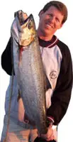
I know I've been out of the loop (this is beerman1981, just can't login under the old name, so remember joetucker=beerman). I saw Knuppenburg on your list. Great lake, and I've caught all sorts of fish out of there. Located about a mile West of the summit of White pass, this lake contains a vast array of trout. It is stocked yearly with Brown Trout (roughly around May). But, it also has Rainbow and Brook trout. Additionally, I have caught one fish out of this lake that I still cannot identify. Kastmasters are my number one choice. Here's a few pictures of Knuppenburg for you guys. Here's some pictures. In addition, I've got some more stuff I can spread in the alpine lakes, regarding Granite Lake, Twin Sisters Lakes, Lilly Lake, etc. I'll keep providing information.... I know I've been gone a while, but I've got a lot to share. Anyways, here's Knuppenburg. And by the way, if anyone can identify the last fish in the pictures, it would help solve a mystery.
- Attachments
-
-
-
-
joetucker803
- Petty Officer
- Posts: 47
- Joined: Fri Mar 13, 2015 10:44 pm
Re: New Alpine Lakes/Maps
oops, make that the first fish that is unidentifiable.
-
Mike Carey
- Owner/Editor
- Posts: 7765
- Joined: Sun Apr 01, 2007 10:56 am
- Location: Redmond, WA
- Contact:
Re: New Alpine Lakes/Maps
Updated the Lake Index with these pics, thanks!
"Takers get the honey, Givers sing the blues".
-
joetucker803
- Petty Officer
- Posts: 47
- Joined: Fri Mar 13, 2015 10:44 pm
Re: New Alpine Lakes/Maps
Hey Mike!
I have another Yakima County Alpine lake if you wish to add it to Yakima County's register. Granite Lake. This one is be accessed by vehicle -- but it's extremely rough! I have a 2006 4Runner, and there are places a person needs to be careful with their undercarriage. The lake can be reached via Chinook Pass. Take the Bumping Lake Road (FS1800). Follow that for roughly 14 miles. At approximately 13.5 miles the road will come to split. Right stays on FS1800 and this is what you want to do. Left will take you up Deep Creek to the Twin Sisters Trail. After the Y, the turn off to Granite Lake is about a mile away. The turn off is FS1809, and I do not recall if it is marked or not, but like I said, it's only about a mile past the split in the road, and is also the only left hand turn on this section of road, so you cant miss it. Up until this point, the road has been paved and you have been on a some gravel and a few potholes. From here, hang on! From the 1809 turn off, it will be 3.5 miles of washouts, rocks, dips, bumps, etc. It's nothing technical if you take your time, and any stock 4 wheel drive will make it in unscathed. DON'T TAKE A CAR. I usually put my 4Runner in four low and just creep into the lake. The last time I went, my wife actually got out at one point and started walking almost as fast as I was driving! LOL.
Once you reach this lake, you will know why you have subjected your vehicle to the road. IT IS BEAUTIFUL and very remote -- a great place to escape reality for a day or two. I want to camp here sometime. All I've ever caught here are Brook Trout, and I believe Brook Trout are the only fish in this lake, as this is all I have caught; however, I have yet to read anything from Fish and Wildlife says otherwise, so there could be Cutthroat or Rainbows????
Anyways, a great alpine lake, without having to even hike. Just go slow and use caution on the 1809 road!
Joe(aka beerman)
- Attachments
-
-
- 3.5 miles of this
-
- Granite Lake
-
Mike Carey
- Owner/Editor
- Posts: 7765
- Joined: Sun Apr 01, 2007 10:56 am
- Location: Redmond, WA
- Contact:
Re: New Alpine Lakes/Maps
thanks, I will get Granite lake added soon. Nice additions to the database. 
"Takers get the honey, Givers sing the blues".
Re: New Alpine Lakes/Maps
Hi Mike,
Where's the database to take a look at? I'm taking my 16 year old on his first backpacking trip. Looking at the Rainier/Packwood area. Would like to at least direct our trip to some lakes that have fish in them!
Where's the database to take a look at? I'm taking my 16 year old on his first backpacking trip. Looking at the Rainier/Packwood area. Would like to at least direct our trip to some lakes that have fish in them!