Hey folks
I'm planning a camping trip for a night or 2 at Coal Lake and taking the family.Just wondering if anyone has been up there recently. Snow pack? Fish bite? Any info is great.I havn't been up here in many years....infact,this trip is my wife's idea.
Pretty sweet:cheers: !!!
Thanks again
Kevin
Coal Lake,Snohomish County
Forum rules
Forum Post Guidelines: This Forum is rated “Family Friendly”. Civil discussions are encouraged and welcomed. Name calling, negative, harassing, or threatening comments will be removed and may result in suspension or IP Ban without notice. Please refer to the Terms of Service and Forum Guidelines post for more information. Thank you
Forum Post Guidelines: This Forum is rated “Family Friendly”. Civil discussions are encouraged and welcomed. Name calling, negative, harassing, or threatening comments will be removed and may result in suspension or IP Ban without notice. Please refer to the Terms of Service and Forum Guidelines post for more information. Thank you
Coal Lake,Snohomish County
http://www.nwburn.org/
Musky Mayhem Tackle
www.muskymayhemtackle.com
www.petemaina.com
Ken's Custom Lures
Musky Mayhem Tackle
www.muskymayhemtackle.com
www.petemaina.com
Ken's Custom Lures
-
The Quadfather

- Rear Admiral One Star
- Posts: 3868
- Joined: Tue May 08, 2007 2:27 pm
- Location: Carkeek Park, North Seattle
- Contact:
RE:Coal Lake,Snohomish County
Kevin,
This is a lake I have been to many times over the years. I think it was this last spring that I went up that way... but due to harsh winter the whole area was devestated with storm damage. I had my kids so we didn't hike in. Kids could do it, but we weren't prepared to hike that day.
( I am not at all telling you not to go) Just a couple of things.... If you can, about 1/2 mile before the turn off to Coal lake you will see the "Big Four Ice Caves" You really should try and get in there. the hike from the parking is flat and only about 1/4 mile. Fine for kids. The ice caves are best more in August,, but it still should very nice. Google it for pics.
However the winter storm damage had blown out the foot bridge over the river... they may have put something else together for people.
When you get to the turn off for Coal lake, you can only go by car about 1 mile maybe, then the road had washed off the hillside to some degree.. by the storm. It would be an easy hike up to the lake from that point because you are walking on what is a car traveled logging type road. Coal lake is 50' from the road. Coal lake was generally the least producing of fish from the lakes on that road, but certainly I have caught small fish in there, trout 9-11" etc.
About 100' past Coal is another trail head to the next lake, (name escapes me) I haven't been into that one ever, but I'm sure it is within a 2 mile hike at most.
The better of the lakes was another 500' up the road at the end of the road. The trail head goes to Independance lake, I think this one is 1.5 miles from the trail head. This one I used to catch nice rainbows in 12-14", (but for alpine lakes those are pretty good size trout) The alpine lake trout are just fiestier, If you've got a fly rod def. bring it. If you're going hard core with some buddies, I'd pack a float tube. You could at least have it on Coal lake.
Of course there is another lake beyond Independance and over the ridge, but considering where you have to leave your car, that may be farther than you want to go.
Coal lake has 3 or 4 camp sites, the lake access is a little limited. maybe hard to backcast a fly, but you can throw spinners.
Independence lake has maybe 3 camp spots at the enry end of the lake, and another 3-5 at the far end. Better shore access, and one side has a sheer rock wall that you can get up on fish a steep drop off. A log jam at the entry end which I did well by climbing out on the logs and fishing.
Actually what you should do is just call the Verlot ranger station and ask them the condition of the road into Coal, and about snow pack etc. They will exactly what's been fixed or not.
Check out http://www.fs.fed.us/r6/mbs/about/drd.shtml
Look closely it's called the Verlot public service center.
All that being said, it's probably been 8 years since I have fished these lakes, so of course anything goes year to year.
If you've got any other questions just PM me.
Last edited by Anonymous on Sun Jul 20, 2008 6:56 pm, edited 1 time in total.
"Honey Badger don't care.. Honey Badger don't give a ....."
4r7wHMg5Yjg
4r7wHMg5Yjg
RE:Coal Lake,Snohomish County
I appreciate the solid info. I havn't been here in many years,I didn't know about the storm damage(good to know)
I'll bring my spinning and fly gear.Want to do some fly fish'n but have way more confidence in my standard gear.
Thanks again:salut:
I'll bring my spinning and fly gear.Want to do some fly fish'n but have way more confidence in my standard gear.
Thanks again:salut:
http://www.nwburn.org/
Musky Mayhem Tackle
www.muskymayhemtackle.com
www.petemaina.com
Ken's Custom Lures
Musky Mayhem Tackle
www.muskymayhemtackle.com
www.petemaina.com
Ken's Custom Lures
-
fishnislife

- Admiral
- Posts: 2630
- Joined: Fri May 11, 2007 8:33 am
- Location: Kitsap County
- Contact:
RE:Coal Lake,Snohomish County
WOW! Great info. quad.
kevinb, did you guys go yet? How was it?
fishnislife
kevinb, did you guys go yet? How was it?
fishnislife

Fish, Baits, Tournaments & BBQ's, Scenic Pictures, Hunting and World Record Pix:
http://s27.photobucket.com/albums/c176/fishnislife/" onclick="window.open(this.href);return false;
RE:Coal Lake,Snohomish County
Not yet,my wife and I are on vacation but came home early due to the passing of a friend and fellow firefighter.fishnislife wrote:WOW! Great info. quad.
kevinb, did you guys go yet? How was it?
fishnislife
We will be going there soon though and looking forward to it. I'll keep you guys posted and some pics too
http://www.nwburn.org/
Musky Mayhem Tackle
www.muskymayhemtackle.com
www.petemaina.com
Ken's Custom Lures
Musky Mayhem Tackle
www.muskymayhemtackle.com
www.petemaina.com
Ken's Custom Lures
-
The Quadfather
- Rear Admiral One Star
- Posts: 3868
- Joined: Tue May 08, 2007 2:27 pm
- Location: Carkeek Park, North Seattle
- Contact:
RE:Coal Lake,Snohomish County
Just an update to this thread... I had a wild hair and I went up and hiked into Coal lake today. This was a very late start in the day, so it was only an hour fish time. I didn't even start the hike until 2:45 pm. but I can give some updates to the trail/area etc.
First off, when I posted earlier about the Big Four Ice Caves, and I said that the bridge was out due to storm damage etc. Well... yes it still is,, but about 1/4 miles down the river there is a log that crosses the river and acts as the new bridge. I read of a family who had their 5 y/o crossing it, and a 3 y/o who held moms' hand. (Take that for whatever you want... but it souinds like def. a couple of adults would be safe)
About 1000' past Big Four Caves is the turn off to Coal lake Rd. You can take it up exactly 1.8 miles, and then there is room to park about 3 or 4 vehicles.
From there I would say it was a 2 mile hike. It is all on a pretty decent graveled logging road, but there are a few trees across it, and the alder trees are starting to encroach. The wash out in the road is really bad. I just don't see how the Forest Service, or who ever does this stuff can have the funds to repair this section of road.
The walk from the car took me 55 minutes. I was way over loaded for the time I actually had at the lake. I was carrying a Super Fat Cat float tube inflated on my back, right hand carried a back pack with numerous items including 4 reels, and way to much tackle. Left hand carried a pvc pipe rod carrier with both a fly rod and a spinning rod. When I finally got to the lake it started raining, and the cloud cover was about 20' above the lake, very drizzly weather.
I put the tube in and floated the entire lake sticking about 20' off of shore. I am not much of a fly fisherman, I mean that I have all the stuff... but I don't really know what I'm doing, and I'm not usually successful. However I only fished two flies, and all the action was on an olive wooly bugger.
I had strikes on my first cast with my new Orvis travel rod, that was cool. I wound up catching 3 brookies all of 7". whoo hoo. They are such a pretty trout though. I had numerous hits from fish who just couldn't deal with the size of the fly.
There is a pit toilet, and probably 4-5 tent spots. The lake is pretty accessible from shore, I was wrong in my first post in saying that it was not. I think that you could hoof it around the whole lake. If anyone goes, you've got to scramble over to the opposite side of the lake and fish from the rock slide. The water is pure alpine lake water, with incredible visability. 15-20'.
The water was cold as **** I tubed it in shorts, OMG. probably not the safest thing being by myself. If I had an accident, I don't think that you can function after even 2 minutes in water that is prob. 40 deg, even hiked in wearing a PFD. There were a couple of snow field at the lake, but not any issue at all.
Anyway, sorry for the ramble, but I really dig this area, and I was intrigued to see a thread from Kevinb about maybe going up there.
Oh yeah... My brand newly bought on the way there.... (blankin') digital camera came with dead batteries. I was so looking forward to some pics. for the alpine lake photos section.](./images/smilies/eusa_wall.gif "Brick wall")
First off, when I posted earlier about the Big Four Ice Caves, and I said that the bridge was out due to storm damage etc. Well... yes it still is,, but about 1/4 miles down the river there is a log that crosses the river and acts as the new bridge. I read of a family who had their 5 y/o crossing it, and a 3 y/o who held moms' hand. (Take that for whatever you want... but it souinds like def. a couple of adults would be safe)
About 1000' past Big Four Caves is the turn off to Coal lake Rd. You can take it up exactly 1.8 miles, and then there is room to park about 3 or 4 vehicles.
From there I would say it was a 2 mile hike. It is all on a pretty decent graveled logging road, but there are a few trees across it, and the alder trees are starting to encroach. The wash out in the road is really bad. I just don't see how the Forest Service, or who ever does this stuff can have the funds to repair this section of road.
The walk from the car took me 55 minutes. I was way over loaded for the time I actually had at the lake. I was carrying a Super Fat Cat float tube inflated on my back, right hand carried a back pack with numerous items including 4 reels, and way to much tackle. Left hand carried a pvc pipe rod carrier with both a fly rod and a spinning rod. When I finally got to the lake it started raining, and the cloud cover was about 20' above the lake, very drizzly weather.
I put the tube in and floated the entire lake sticking about 20' off of shore. I am not much of a fly fisherman, I mean that I have all the stuff... but I don't really know what I'm doing, and I'm not usually successful. However I only fished two flies, and all the action was on an olive wooly bugger.
I had strikes on my first cast with my new Orvis travel rod, that was cool. I wound up catching 3 brookies all of 7". whoo hoo. They are such a pretty trout though. I had numerous hits from fish who just couldn't deal with the size of the fly.
There is a pit toilet, and probably 4-5 tent spots. The lake is pretty accessible from shore, I was wrong in my first post in saying that it was not. I think that you could hoof it around the whole lake. If anyone goes, you've got to scramble over to the opposite side of the lake and fish from the rock slide. The water is pure alpine lake water, with incredible visability. 15-20'.
The water was cold as **** I tubed it in shorts, OMG. probably not the safest thing being by myself. If I had an accident, I don't think that you can function after even 2 minutes in water that is prob. 40 deg, even hiked in wearing a PFD. There were a couple of snow field at the lake, but not any issue at all.
Anyway, sorry for the ramble, but I really dig this area, and I was intrigued to see a thread from Kevinb about maybe going up there.
Oh yeah... My brand newly bought on the way there.... (blankin') digital camera came with dead batteries. I was so looking forward to some pics. for the alpine lake photos section.
Last edited by Anonymous on Tue Jul 29, 2008 9:47 pm, edited 1 time in total.
"Honey Badger don't care.. Honey Badger don't give a ....."
4r7wHMg5Yjg
4r7wHMg5Yjg
-
cole steffens
- Petty Officer
- Posts: 80
- Joined: Sat Apr 28, 2007 3:54 pm
- Location: 7 lakes
RE:Coal Lake,Snohomish County
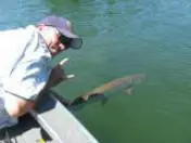
boy remember the days when you used to be able to drive right up to that nice little lake it the last two year ive been up there the erosion has gotten worse an worse . as for my luck i was up there about a week ago an caught an release one small rainbow hopefully better luck next time ihavent fished independence maybe next time ill hike up there
if we are good to are lakes and streams they will be good to us