
Hmmm, ya, you'd think that, I wasn't. lol I saw the depth and only thought, "That's too deep". HaHaHa But it might be fine during the winter.Larry3215 wrote:I would think it starts close to shore, so it should be shallower closer in?Amx wrote:Great pictures. I really like that dock situation. Too bad it's too deep.
I've done the screen capture a couple times, but not on depth stuff, only on the properties/software on the computer thing inside the depth finders (2) to compare what makes them work different and so getting different chart images. and need to practice it a FEW times for the depth stuff.
Sonar interpretation?
Re: Sonar interpretation?
Tom.
Occupation: old
Interests: living
Occupation: old
Interests: living
-
TrackerPro16
- Commander
- Posts: 387
- Joined: Sun Jan 08, 2017 4:44 am
Re: Sonar interpretation?
Next time out I will go at it from N to S and see how far in it goes. With the Panoptix looking forward I can make sure not to hit anything if it gets too shallow. I doubt it would be very forgiving... They lower the lake during the winter so this is probably a good time to check it out.
Re: Sonar interpretation?
I haven't fished Washington since 2010 or 2011. I should go back someday.
Tom.
Occupation: old
Interests: living
Occupation: old
Interests: living

Re: Sonar interpretation?
I was looking at Google earth and my Charts to try to see if there were any notes or old pics. Does this look like the right place? if so, it doesnt make it to shore, but the shallow end might be anywhere from 15 to 20 ft deep or so.
-
TrackerPro16
- Commander
- Posts: 387
- Joined: Sun Jan 08, 2017 4:44 am
Re: Sonar interpretation?
You Sir, are amazing! That has to be it! How cool is that! Interesting old picture. I wonder if they could move it in to shore or if it was moored there perminantly? I work on the Flightline and will ask some of the long time Boeing people if they remember.
I should have thought about old overhead pictures as the Boeing office facilities walls are plastered with old pictures. Doh! Most every older Boeing facility has old pictures of thier area posted.
I should have thought about old overhead pictures as the Boeing office facilities walls are plastered with old pictures. Doh! Most every older Boeing facility has old pictures of thier area posted.
-
TrackerPro16
- Commander
- Posts: 387
- Joined: Sun Jan 08, 2017 4:44 am
Re: Sonar interpretation?
It is a big lake with lot's of fish, but I have been skunked... After having the new electronics and REALLY seeing what is down there it is pretty amazing that can even happen.Amx wrote:I haven't fished Washington since 2010 or 2011. I should go back someday.
I am only 10 miles from it so got an annual pass. Means I don't fish many other lakes unless I am camping but also means I will pop over for a couple hours with the boat on a whim. I don't let people that go with me help put it in or take it out. I have my routine down... Only time someone helped I ended up with a rope wrapped up in my prop.
Re: Sonar interpretation?
Yup, a routine is important, and to keep to it as important. One LITTLE interuption can make you forget something. One day with another new person to bass fishing I forgot to take off the motortoter. It came off while I was idling away from the launch. I wondered what that was and figured it was a stump or something. Back at the truck I couldn't find the toter and knew what'd happened.
If you still haven't caught any Bass in Lake Wa. I should show you some of the areas I use to fish.
If you still haven't caught any Bass in Lake Wa. I should show you some of the areas I use to fish.
Tom.
Occupation: old
Interests: living
Occupation: old
Interests: living
-
TrackerPro16
- Commander
- Posts: 387
- Joined: Sun Jan 08, 2017 4:44 am
Re: Sonar interpretation?
Sideways pics again! I had another on there but it was upside down.
Re: Sonar interpretation?
If it helps, that picture was dated June 1990 by Google. The next one time wise was July 2002 and it was gone then, so it was sunk sometime between those dates.TrackerPro16 wrote:You Sir, are amazing! That has to be it! How cool is that! Interesting old picture. I wonder if they could move it in to shore or if it was moored there perminantly? I work on the Flightline and will ask some of the long time Boeing people if they remember.
I should have thought about old overhead pictures as the Boeing office facilities walls are plastered with old pictures. Doh! Most every older Boeing facility has old pictures of thier area posted.
-
TrackerPro16
- Commander
- Posts: 387
- Joined: Sun Jan 08, 2017 4:44 am
Re: Sonar interpretation?
Well, I feel like a moron... I know I went and looked at the old Boeing photo's when I first got there but have forgotten about them as I walk by them every day. There were at least 4 that showed a dock. Here is a gem showing a B29 being barged.
-
TrackerPro16
- Commander
- Posts: 387
- Joined: Sun Jan 08, 2017 4:44 am
Re: Sonar interpretation?
Been playing with the electronics and am liking them more and more. I have learned to use them when I need them, not stare at them full time.
The detail is pretty amazing. Wish I had gone for the 12" screen instead of the 10" though. Maybe even a 15"!
The detail is pretty amazing. Wish I had gone for the 12" screen instead of the 10" though. Maybe even a 15"!
Re: Sonar interpretation?
I havent gotten to the point I can stop staring at mine yet. As far as a 12 or 15" screen - I need to win that lotto thing first!

Re: Sonar interpretation?
12" is the way to go because you can split screens and still see whats going on. Here are a few of my fav screenshots from this year.TrackerPro16 wrote:Been playing with the electronics and am liking them more and more. I have learned to use them when I need them, not stare at them full time.
The detail is pretty amazing. Wish I had gone for the 12" screen instead of the 10" though. Maybe even a 15"!
Dropshot fish catch

Split screen showing cool rocks and ball of small fish

The Columbia showing river channel, cables, piles and buoys.

Re: Sonar interpretation?
Nice shots! What MFD is that?
Re: Sonar interpretation?
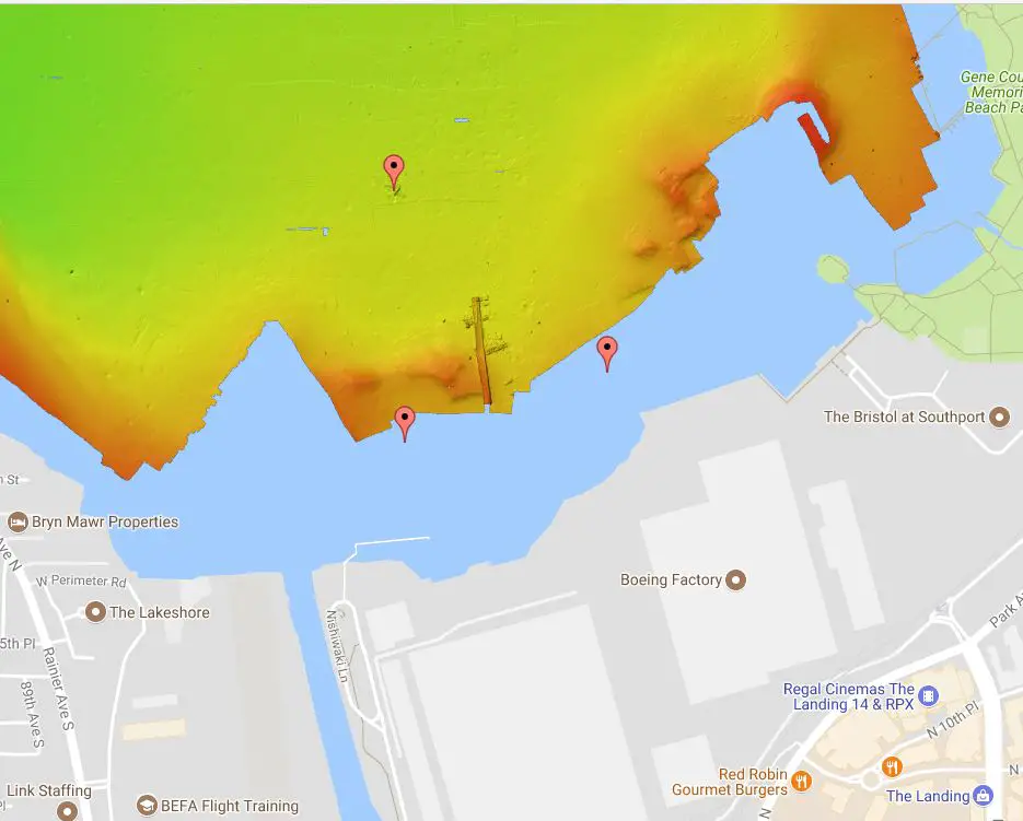
FYI - Puget Sound Divers stitched together side scans of Lake Washington to create an interactive map of the lake bottom complete with markings of known wrecks and other man made items that have sunk to the bottom. Some of the wrecks show up in pretty good detail.
http://pugetsounddivers.com/mappingproject/
At the south end of the lake, there are several underwater structures that one needs to keep an eye out for while trolling. There are old pilings, a section or two of floating bridge spans, a few aircraft and some boats not to mention the standard debris/tree snags that were kicked out by the river when it flooded.
Re: Sonar interpretation?
Thats pretty cool! They even got Trackerpro16's sunken dock!
-
TrackerPro16
- Commander
- Posts: 387
- Joined: Sun Jan 08, 2017 4:44 am
Re: Sonar interpretation?
That is a neat site! If I had seen that earlier I would have avoided it.
Re: Sonar interpretation?
Lowrance HDS 12 Gen2 touchLarry3215 wrote:Nice shots! What MFD is that?
Re: Sonar interpretation?
[quote="G-Man"]FYI - Puget Sound Divers stitched together side scans of Lake Washington to create an interactive map of the lake bottom complete with markings of known wrecks and other man made items that have sunk to the bottom. Some of the wrecks show up in pretty good detail.
http://pugetsounddivers.com/mappingproject/
This is really cool. Will definitely get those coordinates next time I head over there.
http://pugetsounddivers.com/mappingproject/
This is really cool. Will definitely get those coordinates next time I head over there.
-
fishtrembles
- Angler
- Posts: 3
- Joined: Sun Feb 07, 2016 1:47 pm
Re: Sonar interpretation?
Larry, Your posts are great. I've only just started to read them. I have a Humminbird Onyx and need to know more about it and what I can do with it. Just the first post taught me things I didn't know or even thought about. Great job can't wait to read on.
Fishtrembles
Fishtrembles